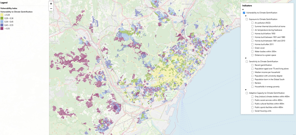
Residents across the Barcelona metropolitan area can now check a free, neighbourhood-by-neighbourhood and block-by-block map of vulnerability to climate gentrification, developed by researchers at the Institute of Environmental Science and Technology of the Autonomous University of Barcelona (ICTA-UAB).
The tool covers 36 municipalities and is intended to identify where the combination of extreme heat, social vulnerability and limited capacity to adapt may create greater displacement pressure. It is a measure of vulnerability, not a prediction that a particular area will gentrify.
For residents and local planners, the map provides a way to compare conditions in their area while cities plan measures to reduce heat and expand climate-resilient infrastructure.
Index covers 2,051 census tracts
The research behind the map, published in the Journal of City Climate Policy and Economy, applied a composite spatial index to 2,051 census tracts across the metropolitan region.
It combines spatial indicators with input from municipal practitioners and grassroots organisations. The framework assesses three elements: exposure, sensitivity and adaptive capacity.
- Exposure: the extent to which places face urban heat.
- Sensitivity: social conditions that can make residents more affected by heat and housing pressure.
- Adaptive capacity: the resources available to respond to these pressures.
“Climate adaptation strategies in cities increasingly risk reinforcing housing inequalities through climate gentrification.”Study published in the Journal of City Climate Policy and Economy
The study found that high vulnerability was concentrated in peripheral municipalities where high exposure coincided with greater social sensitivity and lower adaptive capacity. Researchers also reported different priorities among participants: municipal practitioners placed more emphasis on infrastructure, while community groups stressed structural inequality and the risk of displacement.
Why heat adaptation can raise housing pressure
The researchers define climate gentrification as the displacement of vulnerable residents associated both with climate impacts and with adaptation measures that can make cooler, more resilient neighbourhoods more desirable and more expensive.
The map is part of the [ClimateJusticeReady feature](https://www.bcnuej.org/feature-climatejusticeready/), which examines the relationship between heat, housing and environmental justice. Residents can use the online feature to explore the project’s maps and information on heat and housing inequality in metropolitan Barcelona.
Reported by utppublishing.com, bcnuej.org, Lisa Hannuschke, eurekalert.org, scienmag.com, Amalia Calderón Argelich, Àlex Rebollo, sostenible.cat, UAB, Galia Shokry, frontiersin.org, phys.org, UAB - Universitat Autònoma de Barcelona, El Periódico Barcelona.